About the project
It is widely recognised that developments driven by national or high-level policies to achieve the Sustainable Development Goals (SDGs) may lead to development inequalities between segments of society within a country or region. For instance, water quality protection measures for downstream water consumers at a river basin could require upstream riparian fishermen and farmers to give up their traditional livelihoods. Decision-makers, therefore, need to develop better-informed policies to achieve cross-scale equitable development by minimizing trade-offs and maximizing synergies between the SDGs
Motivated by the above hypothesis, a group of researchers from the University of Glasgow and Loughborough University in the UK, Nankai University, in China, and the Institute for Global Environmental Strategies (IGES) in Japan initiated this project entitled "River basins as 'living laboratories' for achieving sustainable development goals across national and sub-national scales”. This two and a half-year project, funded by the UK’s Natural Environment Research Council (NERC), National Natural Science Foundation of China (NSFC), and the Japan Science and Technology Agency (JST), intends to improve the understanding of human-environment interactions by providing scientifically-grounded, policy-relevant information on the synergies and trade-offs between selected SDGs and targets at the sub-national level. The river basin scale, with the Luanhe River Basin in China as a case study, is the project’s unit of analysis to represent the sub-national scale and constitutes an ideal geography for the study of human-environment interactions. This will be done through state-of-the-art modelling and analysis approaches to improve the understanding of the hydrology, sediment transport, and ecosystem services under various scenarios of large river basin development planning and land-use change, actively engaging with relevant stakeholders, and by extending the SDG Interlinkages Analysis and Visualisation Tool developed by IGES to the basin scale. With this information, the project will assess how observed and projected changes relate to various interlinked SDGs and targets from both spatial and temporal perspectives. Results from this research will be relevant to other basins in China and similar basins across the world.
Study Area
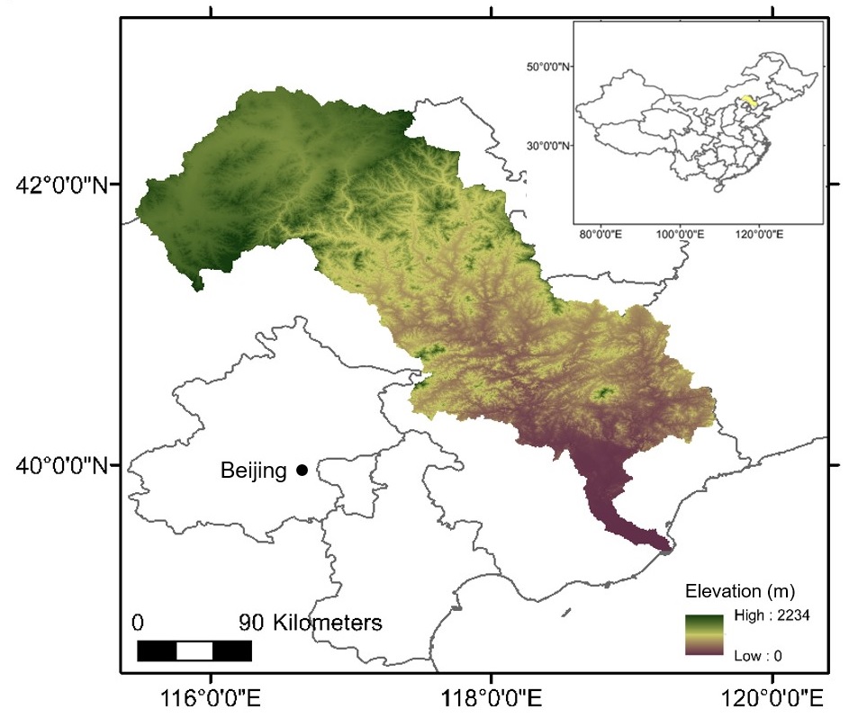
The Luanhe River Basin covers an area of approximately 45,000 km2 in the northeast of the North China Plain (see Figure 1). The basin is located across three provinces: Inner Mongolia Autonomous Region, Hebei Province and Liaoning Province and contains three main types of landforms: plateau, mountain, and plain. The basin is an important water supply source for Tianjin Municipality, a large metropolis with a population of over 15 million people. It has a temperate semi-arid continental monsoon climate, with average annual precipitation of between 400 – 700 mm per year (depending on location), most of which occurs from June to September each year.

Figure 1: Luanhe River Basin, China
Source: Luanhe Living Lab (https://luanhelivinglab.home.blog/)
Project funding
