Framework of the project’s work packages
To investigate how developments driven by national policies aimed at achieving the Sustainable Development Goals (SDGs) may lead to development inequalities between segments of society at the river basin level, five interconnected work packages (WP) with specific objectives were designed. WP1 investigated historical changes in land use at the basin scale and developed future land-use change scenarios for China’s Luanhe River Basin (LRB) by engaging with a range of stakeholders. WP2 modelled flood risk and impacts under various land use and infrastructure change scenarios in the LRB. WP3 evaluated the main ecosystem services and disservices derived from various land use changes in the LRB. WP4 refers to the development of an SDG interactive tool for river basins. The framework of the WPs and their connections is provided in Fig. 1.
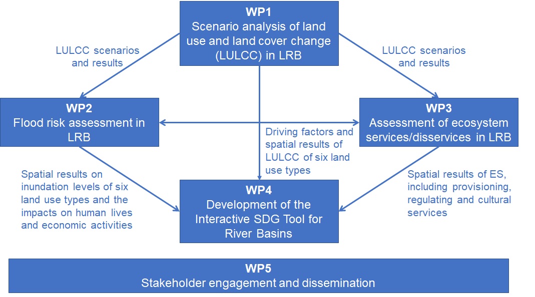
Figure 1: Framework of the project’s work packages
WP1: Scenario analysis of land use and land cover change (LULCC) in LRB. The LULCC scenarios were developed based on different socio-economic development and environmental protection targets, local plans and policies in the LRB, and the results from a stakeholders’ workshop in Tianjin, China. LULCC under four future scenarios for 2015–2030 was simulated using the CLUMondo model, a model for the assessment of the dynamics of spatial land system change, based on the land system map of the LRB in 2000 and other statistical data (refer to Xu, Renaud, et al. (2021) for details). Results from WP1 on LULCC scenarios were used in WPs 2‒4.
WP2: Flood risk assessment in LRB. The High-Performance Integrated hydrodynamic Modelling System (HiPIMS) model (Xia et al., 2019) was set up using openly available digital elevation model (DEM) data and the land use maps generated from WP1 to predict the inundation maps and assess flood impact. The severe flood event caused by the heavy rainfall brought in by Typhoon Saola and Damrey in 2012 was simulated for model calibration. Considering also two climate scenarios, Representative Concentration Pathway (RCP) 4.5 and RCP 8.5, as well as construction of key infrastructure (i.e., dams and reservoirs), a total of 28 flood scenarios were simulated for the projected LULCC scenarios from WP1 (refer to Zhao et al. (2021) for details). The simulation and impact analysis results, in terms of the inundation levels/extents of six major land use types and flood impact on human lives were used to support development of the Interactive SDG Tool for River Basins in WP4.
WP3: Assessment of ecosystem services/disservices in LRB. Ecosystem services, including provisioning, regulating and cultural services, provided by the six land system types in the LRB were assessed based on stakeholder participatory capacity matrices (refer to Xu, Barrett, et al., (under review) for details). Based on the LULCC results from WP1, changes in the various ecosystem services were assessed and used to develop the Interactive SDG Tool for River Basins in WP4.
WP4: Development of the Interactive SDG Tool for River Basins. The SDG Interlinkages Analysis and Visualisation Tool (hereafter referred to as the SDG Interlinkages Tool) was developed to enable visualisation of quantitative SDG interlinkages at the national level for 27 countries in Asia and Africa (Zhou et al., 2021). The SDG Intetlinkages Tool was extended to the river basin scale to reflect specific features of SDG interactions in river basins. These include the spatial differences (such as upstream vs. downstream areas) in SDG interlinkages at the basin scale and the interactions among LULCC, climate change, ecosystem services, land degradation and soil erosion, water availability, sediment yield, irrigation water use, water quality and groundwater level, etc. An Interactive SDG Tool for River Basins was developed as one of the main outputs of the “Luanhe Living Lab” project which integrates all the other WPs.
WP5: Stakeholder engagement and dissemination. The main objective of WP5 is to ensure optimal stakeholder engagement, efficient scientific exchange among project partners and that project outputs are tailored and delivered to a wide audience (“Luanhe Living Lab” Project Team, 2021).
For detailed methodologies,please see Renaud, et al. (2020).
Methodology of the SDG Interlinkages Tool and its extension to the basin scale
The methodology of the SDG Interlinkages Tool for the identification, quantification and visualisation of SDG interlinkages at the national level and its extension to the basin scale includes four steps (Zhou et al.,2021), as shown in Fig. 2
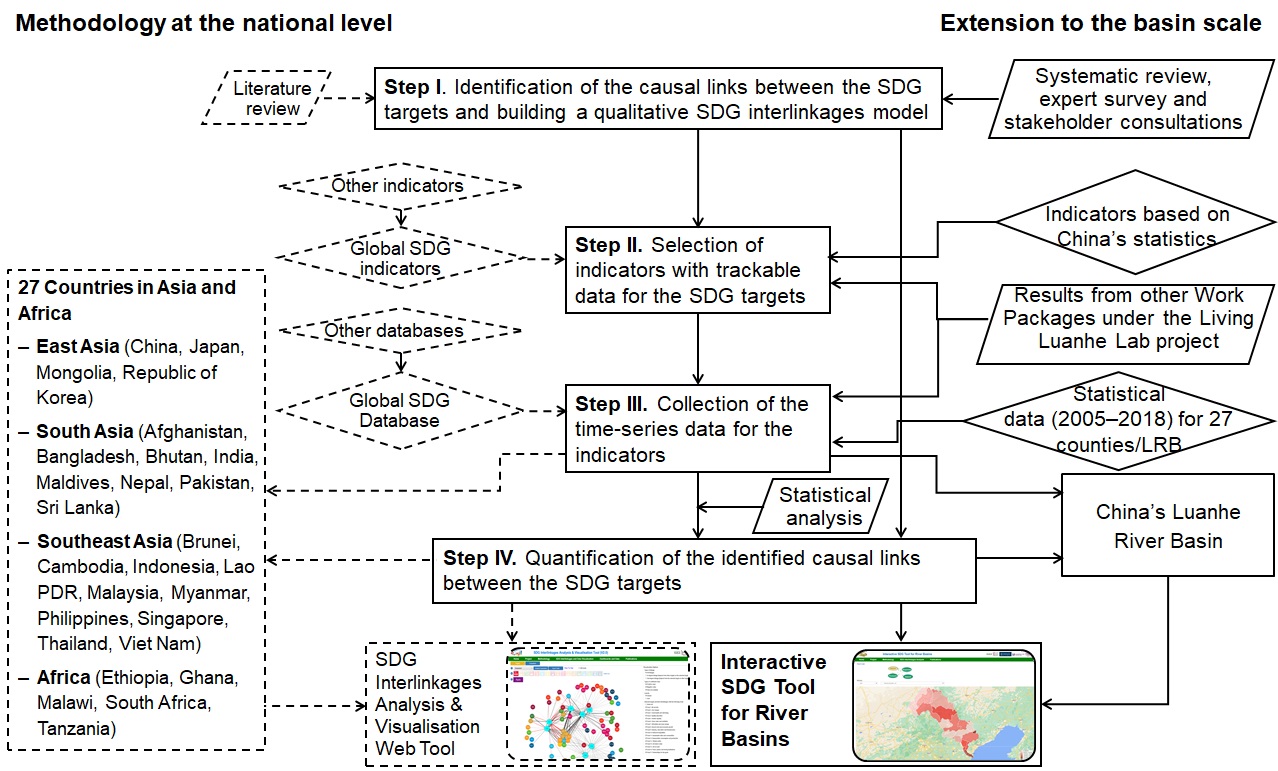
Figure 2: Methodology on the identification, quantification and visualisation of the SDG interlinkages at the national level and its extension to the basin scale
Step I refers to identification of the interlinkages between the SDG targets and building a qualitative SDG interlinkages model. Pairwise linkages, defined by causation, indicate the impacts of one target on the other. Identification of the causal relationships for the study at the national level is based on a literature review (Zhou & Moinuddin, 2017). For the study at the basin scale, a systematic review on the key elements and their interactions for achieving sustainable development in river basins was conducted to build a generic qualitative interlinkage model for river basins. The systematic review was conducted for seven focused areas of the Living Luanhe Lab project – Goal 6 (Clean Water and Sanitation), Goal 7 (Affordable and Clean Energy), Goal 11 (Sustainable Cities and Communities) and Goal 13 (Climate Action) and three specific topics – namely, LULCC, ecosystem services and flood risk. The generic model was further validated and tailored to a case study in China’s Luanhe River Basin (LRB) through an expert survey and stakeholder consultations (see Zhou et al. (2021) for details).
Step II refers to the identification of indicators with trackable data for the SDG targets. At the national level study, the global SDG indicators (United Nations Statistical Commission, 2018) were used. If indicators or relevant data were not available, other proxy indicators (e.g., the World Bank’s World Development Indicators) were used. For the case study in the LRB, indicators for the variables defined in the qualitative SDG interlinkages model were identified based on various statistics in China and the results from other work packages under the ‘Living Luanhe Lab’ project (see Fig. 1).
Step III Step III refers to the collection of time-series data for the identified indicators. For the national level study, the Global SDG Database (UNDESA, 2019) was used as the major data source. For the case study in the LRB, time-series data (2005-2018) for the indicators identified by Step II was collected for 27 counties located in the LRB based on various statistics in China and the results from WPs 1–3 (see Fig. 1). Please see Zhou et al. (2021) for details.
Step IV refers to the quantification of SDG interlinkages built in Step I. A Pearson correlation analysis was conducted to quantify the pairwise linkages using the time-series data collected for the indicators from Step III. The correlation coefficient, ranging between [− 1, 1], refers to the linear relationship between the pairs – a positive coefficient representing a positive relationship and a negative coefficient representing a negative relationship.
Based on the methodology of SDG interlinkage analysis at the basin scale, the Interactive SDG Tool for River Basins, a free online tool, was developed(see Zhou et al. (2021) for details).
The DPSIR framework as a basic structure of the SDG interlinkages model
The Driver-Pressure-Impact-Response (DPIR) framework, a simplified version of Driver-Pressure-State-Impact-Response (DPSIR), was used as a base for constructing the SDG interlinkages model owing to its efficacy in enabling communication among various stakeholders. DPSIR was developed originally by the European Environment Agency (EEA, 1999) to manage environmental indicators for monitoring the state of the environment (Kristensen, 2003). As a causal chain framework, DPSIR helps present the causal relationships between the human system and the environment, as well as within the socio-economic sub-systems and the environment sub-systems through the dynamics among five components. As drivers, human activities (e.g., urbanisation and irrigation) exert pressures on the environment (e.g., water pollution and water use intensity), which result in changes in state of the environment (such as chemical oxygen demand in fresh water and frequency of water shortages, etc.). These changes may cause ecological degradation (e.g., of the provisioning services of water-related ecosystems) and associated economic and social impacts (e.g., health impacts). Society then responds in order to address the environmental degradation and manage the risks through mitigation, adaptation and prevention measures (e.g., pollution abatement and water supply prices). DPSIR is a useful tool to help identify the problems (pressures and impacts), their causes (drivers) and the solutions (responses).
Useful links
Luanhe Living Lab blog: https://luanhelivinglab.home.blog/
Project twitter: https://twitter.com/riversdgs1?lang=en-gb
IGES SDG Interlinkages Tool: https://sdginterlinkages.iges.jp/visualisationtool.html
References
EEA. (1999). Environmental indicators:Typology and overview — European Environment Agency. https://www.eea.europa.eu/publications/TEC25
Kristensen, P. (2003). EEA core set of indicators.
“Luanhe Living Lab” Project Team. (2021). Research Brief: Lessons learnt from synergies and trade-offs between SDGs at the sub-national scale. https://sdginterlinkages.iges.jp/luanhe/index.html
UNDESA. (2019). United Nations Global SDG Database. United Nations Department of Economic and Social Affairs. https://unstats.un.org/sdgs/unsdg
United Nations Statistical Commission. (2018). SDG Indicators — Global indicator framework for the Sustainable Development Goals and targets of the 2030 Agenda for Sustainable Development. United Nations. https://unstats.un.org/sdgs/indicators/indicators-list/
Xia, X., Liang, Q., & Ming, X. (2019). A full-scale fluvial flood modelling framework based on a high-performance integrated hydrodynamic modelling system (HiPIMS). Advances in Water Resources, 132, 103392. https://doi.org/10.1016/J.ADVWATRES.2019.103392
Xu, J., Barrett, B., & Renaud, F. (2021). Ecosystem services and disservices in the Luanhe River Basin in China under past, current and future land uses: implications for the Sustainable Development Goals. Sustainability Science.
Xu, J., Renaud, F. G., & Barrett, B. (2021). Modelling land system evolution and dynamics of terrestrial carbon stocks in the Luanhe River Basin, China: a scenario analysis of trade-offs and synergies between sustainable development goals. Sustainability Science 2021, 1, 1–23. https://doi.org/10.1007/S11625-021-01004-Y
Zhao, J., Liang, Q., Chen, H., Xia, X., Xu, J., Hoey, T., Barrett, B., Renaud, F., Bosher, L., & Xin, Z. (2021). Large-scale flood risk assessment under different development strategies: the Luanhe River Basin in China. Sustainability Science.
Zhou, X., & Moinuddin, M. (2017). Sustainable Development Goals Interlinkages and Network Analysis: A practical tool for SDG integration and policy coherence. Institute for Global Environmental Strategies (IGES). https://pub.iges.or.jp/pub/sustainable-development-goals-interlinkages
Zhou, X., Moinuddin, M., & Li, Y. (2021). SDG Interlinkages anlaysis and visualisation tool (V4.0). Institute for Global Environmental Strategies (IGES). https://sdginterlinkages.iges.jp/visualisationtool.html
Zhou, X., Moinuddin, M., Renaud, F., Barrett, B., Xu, J., Liang, Q., Zhao, J., Xia, X., Bosher, L., Huang, S., & Hoey, T. (2021). Development of an SDG interlinkages analysis model at the river basin scale: A case study in the Luanhe River Basin, China. Sustainability Science.